
Southern California Wildfires, 2007
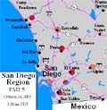
Witch - Guajito - Poomacha Complex
Harris, Horno, Rice Canyon, Coronado Hills and McCoy Fires
More information being added. Activities for students also being developed. Please let us know if can suggest a good observational resource.
Witch - Guajito - Poomacha Complex
Harris, Horno, Rice Canyon, Coronado Hills and McCoy Fires
More information being added. Activities for students also being developed. Please let us know if can suggest a good observational resource.
Key Observations
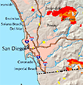
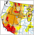
Satellite based maps of fire area by date Date Oct 21 - Nov 2, 2007 Source MODIS Active Fire Mapping Program USDA Forest Service, Remote Sensing Applications Center |
Satellite based images Date Oct 21 - Nov 2, 2007 Source MODIS Active Fire Mapping Program USDA Forest Service, Remote Sensing Applications Center |
Satellite based movies of path and extent of smoke Date Oct 21 - Oct 25, 2007 Source GOES Project Goddard Space Flight Center, NASA |
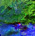
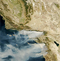
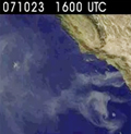
Assorted satellite based images Date Oct 22 - Oct 28, 2007 Source NASA Earth Observatory some high-resolution, some modified satellite images |
Progression of air quality Date Oct 21 - Nov 2, 2007 Source AIRNOW AIRNOW is a cross-agency U.S. Government Web site. |

Explanation of the Santa Ana Winds Comment Check out the FAQ link Source Robert Fovell, Professor of Atmospheric and Oceanic Sciences University of California, Los Angeles |
||||
|
|
|
|
|
|
|
Earth Observatory, NASA
Search for string "Fires in Southern California" for images of Cedar, Paradise, and other fires. Fires - Natural Hazards, NASA Earth Observatory
Fire & Aviation Management
"The Fire and Aviation Management part of the USDA Forest Service is a diverse group of people working to advance technologies in fire management and suppression, maintain and improve the extremely efficient mobilization and tracking systems in place, and reach out in support of our Federal, State, and International fire partners." USDA Forest Service
MODIS Active Fire Mapping Program
"The Fire and Aviation Management part of the USDA Forest Service is a diverse group of people working to advance technologies in fire management and suppression, maintain and improve the extremely efficient mobilization and tracking systems in place, and reach out in support of our Federal, State, and International fire partners." USDA Forest Service and multiple groups
Southern California Geographic Area Coordination Center
"The Southern California Geographic Area Coordination Center (OSCC) is the focal point for coordinating the mobilization of retitles for wildland fire and other incidents throughout the Geographic Area. Located in Riverside, CA, the Center also provides Intelligence and Predictive Services related-products designed to be use by the internal wildland fire community for purposes of wildland fire and incident management decision-making." Southern California Geographic Area Coordination Center |
©2007 by the Earthguide at the University of California San Diego.
All rights reserved.
Last modifed Friday, November 2, 2007