Unusual episodes during the formation of oceanic crust
The Earth's crust continuously forms along a network of oceanic spreading centers that circle the globe. As new seafloor forms, the earth's tectonic plates move apart in opposite directions at these spreading centers. As the tectonic plates move apart, rock is pulled up from depth at the spreading axis and melts as it depressurizes. The molten rock rises to the seafloor and cools to form the layer of crust that paves the ocean floor.
Fig. 5. Seafloor spreading at the Mid-Atlantic Ridge. Basemap adapted from image on Structural Geology and Tectonics website at Duke University, http://www.geo.duke.edu/Research/struct/MAR.html.
Although this process occurs steadily over geologic time (tens or hundreds of thousands of years), on a day-to-day basis the formation of oceanic crust happens in fits and starts - small earthquakes occur as the plates break while pulling apart; some blocks of rocks are pushed up and some drop down; magma is squeezed through the fractures in the rocks and may extrude on the seafloor to form small volcanic cones; and time may pass with very little noticeable change in the landscape.
The spreading centers themselves form broad central ridges that sink steadily with age and distance, starting at crestal heights of about 2,500 m water depth and sinking to typical open ocean depths of 4,000 meters or 12,000 feet. This unevenness of spreading and plate creation usually produces volcanic ridges and fault-bounded hills that rise up to several hundred feet above the surrounding seafloor, called "abyssal hills". These 'abyssal hills' can be thought of as the texture of the young seafloor, as wrinkles atop the broad ridge of oceanic spreading centers.
Fig.6. A topographic section of Mid-Atlantic Ridge. The high flanks on both sides of the rift valley are shown in red. The highest areas are red and the lowest areas are blue. The rift valley is a linear low-lying area between the flanks of the ridge. The large features are covered with smaller-scale features that might be considered "texture". These are the abyssal hills. Image from Kenneth C. Macdonald and Paul J. Fox, University of California, Santa Barbara.
Questions The unusual thing about the area under study is a large mountain, called the Atlantis Massif, just west of the Mid-Atlantic spreading center at 30°N. The peak of the mountain is 1,700 m (5,000') higher than the usual spreading ridge crest. The width of the mountain is 4-6 times greater than that of most abyssal hills. It is clear that this mountain is a new addition to Earth's crust since it is part of very young and newly created seafloor. The mission is to find out why and how it formed. What forces are responsible for the great height to which rock as been uplifted at this site? What caused a change in the usual style of oceanic crustal formation? When might this area return to its normal state? These are the many questions the scientists seek to answer.
Figure 7. Topography of the area around the Atlantis Massif. Red indicates shallower areas than blue. Do you see that the massif is both smoother than the surrounding area and that it has east-west trending corrugations like the surface of a rippled potato chip?
In 1996 Donna Blackman and Joe Cann, who joins this expedition from University of Leeds in the U.K., mapped the Atlantis Massif and recognized that its structure was unusual. Prior to this discovery, geologists had speculated that the way in which mountains form in the southwestern U.S., in an area called the Basin and Range province, could also take place near oceanic spreading centers. The scientists expected this because both settings are places where tectonic plates are being stretched apart - on the continent it just happens more slowly, the crust is thicker, and there's no seawater. Since their discovery in 1996, a number of similar undersea massifs have been charted in other places on the seafloor. Scientists think their formation is an occasional result of the overall plate spreading and creation process. Now the goal is to find out why.
Theory 1
As the two plates move apart at a spreading center, a fault cracks through the crust near the axis. Normally magma would fill the crack and the adjacent plates would inch away by just that amount. If for some reason the magma supply stops for a period of time the crust must stretch to match the plate motion. If the crack is not vertical, it almost never is, the lower part of the crust can be pulled sideways out from under the upper layer along a dipping fault and exposing deeper rocks at the seafloor. Once the load of the upper crust is removed from the lower crust, the balance of forces that act on the plate causes uplift of the high mountain.
Are the corrugations on the top of the mountain grooves or scrape marks that form as the top layer breaks away from the lower layer and slides along the fault? If so, we have a record of how long this has been going on and some information about how rock deform in these undersea conditions. This explanation of the corrugations is the most widely accepted hypothesis at present although unproven. Evidence from rocks and faults in the Basin and Range suggests that it could be correct. Barbara John from the University of Wyoming has worked extensively on settings on land and she will bring her knowledge of the mountain structures to the expedition.
Are the corrugations just smaller fault blocks that jostle within the mountain range like uneven dominoes as the uplift occurs over time? If so, the way we interpret the massif structure is quite different. Jeff Karson has found evidence to suggest that this may be the case from part of a similar massif further to the south in the Atlantic. return to top
Theory 2
As faults form in new
crust seawater can flow into the cracks. If the cracks extend
deep enough, the seawater can come into contact with mantle rocks
that underlie the crust. The minerals (mainly olivine) in this
kind of rock interact with seawater to form a new mineral (serpentine)
that swells in size. This new, less dense material is lighter
than the surrounding rock, which has not been altered by seawater,
so it wants to rise towards the seafloor. This upward push may
help create the high massif.
Deborah Kelley has studied the chemical
interactions between seawater and oceanic rocks and she will use
new evidence collected on the expedition to determine if this
theory can be proven correct (or incorrect!). Joe Cann has also
studied rock samples from undersea mountains elsewhere in the
Atlantic where it appeared that this rising, less dense serpentine
might be pushing up the seafloor. Comparison between his previous
findings and the new observations will help illustrate what is
really going on. return to top
The expedition begins
At the expedition's height, the
decks of R/V Atlantis will become a separate study in group dynamics
as scientists, technicians and the ship's crew work in shifts
around the clock to launch, operate and retrieving the various
submersible vehicles; sort and study retrieved specimens; monitor
scientific instruments and video screens; log data and transcribe
their taped dictations during Alvin dives; strategize for the
next days' activities; and somehow manage to find the time to
eat and sleep. Join us on this journey of exploration to the frontiers
of the seafloor and dive alongside scientists to restless undersea
mountains of the Mid-Atlantic Ridge.
Check out the first transmissions from the ship on this
website November 14'th!


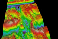 Fig.6. A topographic section of Mid-Atlantic Ridge. The high flanks on both sides of the rift valley are shown in red. The highest areas are red and the lowest areas are blue. The rift valley is a linear low-lying area between the flanks of the ridge. The large features are covered with smaller-scale features that might be considered "texture". These are the abyssal hills. Image from Kenneth C. Macdonald and Paul J. Fox, University of California, Santa Barbara.
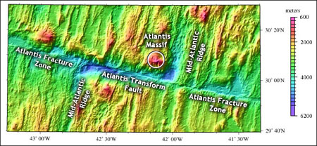 The unusual thing about the area under study is a large mountain, called the Atlantis Massif, just west of the Mid-Atlantic spreading center at 30°N. The peak of the mountain is 1,700 m (5,000') higher than the usual spreading ridge crest. The width of the mountain is 4-6 times greater than that of most abyssal hills. It is clear that this mountain is a new addition to Earth's crust since it is part of very young and newly created seafloor. The mission is to find out why and how it formed. What forces are responsible for the great height to which rock as been uplifted at this site? What caused a change in the usual style of oceanic crustal formation? When might this area return to its normal state? These are the many questions the scientists seek to answer.