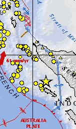
News and information Magnitude 9.1 - Off the West Coast of Northern Sumatra Summary of earthquake and tectonic setting. U.S. Geological Survey Satellite images and tsunami animations QuickBird Images of Tsunami Sites Before and after satellite images. Digital Globe Satellite Images of Tsunami Affected Areas Images acquired and processed by CRISP, National University of Singapore IKONOS image © CRISP 2004 SPOT image © CNES 2004 TERRA Modis image © NASA 2004 (http://modis.gsfc.nasa.gov/) Simulation - December 26 Tsunami in Indian Ocean Animation of simulated tsunami across the Indian Ocean. The link to the animation is near the very bottom of the page. National Institute of Advanced Industrial Science and Technology (AIST), Japan News coverage of the Asian Tsunami, 2004 Indian Ocean Nations to Get Tsunami Warnings CNN.com, Science& Space Asia's Deadly Tsunami MSNBC News The Tsunami in Asia NPR Tsunami: Wave of Destruction ABC News After the Tsunami CNN.com Disaster in Asia CBC News Asia Quake Disaster BBC News World Edition Tsunami in South Asia UN News Centre 2004 Indian Ocean Earthquake Wikipedia Disaster Relief Efforts International Coordination Group for the Tsunami Warning System in the Pacific (ICG/ITSU) Intergovernmental Oceanographic Commission, UNESCO Tsunami in South Asia UN News Centre Tsunami - Bringing Aid to the Survivors International Committee of the Red Cross Tsunami Earthquake Relief USAID American Red Cross Other stories Did animals' 'sixth sense' save them from tsunami? CNN.com |
||||||||
|