
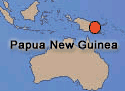
Papua New Guinea
1998 Tsunami
1998 Tsunami
Before the recent tsunami in the Indian Ocean in 2004 -
"tsunami that struck Papua New Guinea on July 17, 1998 may have been the most devastating tsunami in this century. The tremendous loss of life is of great concern to all, including the international scientific community. Scientists continue to examine this event, in an attempt to explain the exceptionally high runups with the ultimate hope of mitigating such disasters in the future."
- U.S. Geological Survey
Scientists believe this massive tsunami was triggered, at least in part, by a large underwater landslide.
What triggers a tsunami? Like the ripples from the impact of a rock thrown into a pond, any event that rapidly displaces large volumes of seawater can trigger the waves of a tsunami. Occasionally a large enough rock, such as an asteroid, might fling itself into the oceans and generate huge ripples in the ocean called tsunami. However, more common triggers are likely to be from more earthly causes.
Common triggers include earthquakes that cause underwater ground rupture, underwater landslides, and the activity of underwater volcanoes. Underwater landslides can be triggered by either earthquakes or gas blowouts near the edges of the continental shelf. The key factor is displacement of water. When lots of rock moves abruptly in the ocean, it displaces water and sets up tsunami waves.
Tsunami are not generally caused by shake-up of water by earthquakes. And no tidal forces are involved so it is bad form to refer to tsunami as tidal waves.
Tsunami risks are high around the Pacific rim because of earthquake and volcanic activity associated with subduction of the Earth's tectonic plates. The Atlantic rim isn't an active tectonic environment so there are fewer earthquakes, volcanoes and tsunami.
Once tsunami are generated, they travel quickly across entire oceans. Detection systems let people know when one is coming their way. With phone communication working at the speed of light, people may have hours to move to higher ground. However, if tsunami are generated just offshore, there's not much time to send out warning. The people of Papua New Guinea were in this situation -- close to the source of the tsunami.
People want to anticipate future events to save lives and minimize loss of property. But before they can pick a solution, they need to find out where these events might happen and how high the water is likely to run up.
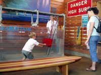
 Testing out the Tsunami Research Tank
See the video of our tank in action.
Image from the Ocean Institute
All that you can do at OI
Scripps scientist Neal Driscoll is interested in finding out more about the risks of nearshore tsunami. Could unstable ground due to buried deposits of offshore gas trigger such an event in southern California? If so, how can we prepare for this hazard?
At the Ocean Institute
The Ocean Institute's Slopes, Slides & Tsunamis! Station highlights the work of Drs. Neal Driscoll and Jeff Babcock. Using recent technological advances, these researchers are just beginning to understand some of the factors that may contribute to massive underwater landslides. Could a strange ice-gas mixture buried within sea floor sediments play a role?
Students and visitors to the Ocean Institute have the opportunity to investigate sea floor slopes, simulate their own underwater landslides, and generate tsunamis.
"tsunami that struck Papua New Guinea on July 17, 1998 may have been the most devastating tsunami in this century. The tremendous loss of life is of great concern to all, including the international scientific community. Scientists continue to examine this event, in an attempt to explain the exceptionally high runups with the ultimate hope of mitigating such disasters in the future."
- U.S. Geological Survey
Scientists believe this massive tsunami was triggered, at least in part, by a large underwater landslide.
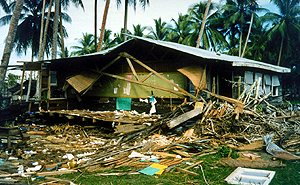 Aftermath of the Papua New Guinea tsunami, July 17, 1998. "A two-story wooden school building that stood near the church at Sissano Mission was carried 65 m by the wave until caught by a grove of coconut palms. The lower floor of the building collapsed, but the upper floor class rooms were preserved. Schoolwork was still hanging on the wall." Photographer - Hugh Davies, University of PNG; NOAA |
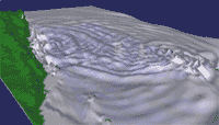 See how the waves generated in this event radiate out from their source. The ripple pattern isn't a perfect ring because of irregularities in the shape of the sea floor. The simulation takes this into account. If the output of the simulation looks like what actually happened, our thinking about how tsunamis are generated may be on the right track. Image and movie courtesy U.S. Geological Survey |
What triggers a tsunami? Like the ripples from the impact of a rock thrown into a pond, any event that rapidly displaces large volumes of seawater can trigger the waves of a tsunami. Occasionally a large enough rock, such as an asteroid, might fling itself into the oceans and generate huge ripples in the ocean called tsunami. However, more common triggers are likely to be from more earthly causes.
Common triggers include earthquakes that cause underwater ground rupture, underwater landslides, and the activity of underwater volcanoes. Underwater landslides can be triggered by either earthquakes or gas blowouts near the edges of the continental shelf. The key factor is displacement of water. When lots of rock moves abruptly in the ocean, it displaces water and sets up tsunami waves.
Tsunami are not generally caused by shake-up of water by earthquakes. And no tidal forces are involved so it is bad form to refer to tsunami as tidal waves.
Tsunami risks are high around the Pacific rim because of earthquake and volcanic activity associated with subduction of the Earth's tectonic plates. The Atlantic rim isn't an active tectonic environment so there are fewer earthquakes, volcanoes and tsunami.
Once tsunami are generated, they travel quickly across entire oceans. Detection systems let people know when one is coming their way. With phone communication working at the speed of light, people may have hours to move to higher ground. However, if tsunami are generated just offshore, there's not much time to send out warning. The people of Papua New Guinea were in this situation -- close to the source of the tsunami.
People want to anticipate future events to save lives and minimize loss of property. But before they can pick a solution, they need to find out where these events might happen and how high the water is likely to run up.
See the video of our tank in action.
Image from the Ocean Institute
All that you can do at OI
At the Ocean Institute
The Ocean Institute's Slopes, Slides & Tsunamis! Station highlights the work of Drs. Neal Driscoll and Jeff Babcock. Using recent technological advances, these researchers are just beginning to understand some of the factors that may contribute to massive underwater landslides. Could a strange ice-gas mixture buried within sea floor sediments play a role?
Students and visitors to the Ocean Institute have the opportunity to investigate sea floor slopes, simulate their own underwater landslides, and generate tsunamis.
Where to find more information:
Tsunami Quickguide
Quick description of tsunami and link to a variety of related resources, including information about the recent Indian Ocean tsunami of 2004.
Earthguide, Scripps Institution of Oceanography
Tsunamis
Explains the reasons for the killer tsunami that struck Papua New Guinea in 1998.
The Why Files, University of Wisconsin
Descriptive Model of the July 17, 1998 Papua New Guinea Tsuanami
Explains the reasons for this killer tsunami. Includes animations showing the results of model simulations.
Western Region Coastal & Marine Geology, U.S. Geological Survey
West Coast & Alaska Tsunami Warning Center
"The West Coast/Alaska Tsunami Warning Center objectives are to rapidly locate and size major earthquakes in the Pacific basin, determine their tsunami potential, predict tsunami arrival times and, when possible, runup on the coast, and provide timely and effective tsunami information and warning bulletins for the Pacific coastal populations of California, Oregon, Washington, British Columbia, and Alaska."
National Weather Service, NOAA
Pacific Tsunami Warning Center
"Established in 1949, the Pacific Tsunami Warning Center (PTWC) in Ewa Beach, Hawai`i, provides warnings for teletsunamis to most countries in the Pacific Basin as well as to Hawai`i and all other US interests in the Pacific outside of Alaska and the US West Coast. Those areas are served by the West Coast / Alaska Tsunami Warning Center (WC/ATWC) in Palmer, Alaska. PTWC is also the warning center for Hawai`i's local and regional tsunamis."
National Weather Service, NOAA
This Dynamic Earth: The Story of Plate Tectonics
Online reference about plate tectonics.
By Kious and Tilling, U.S. Geological Survey
Produced in collaboration with Scripps Institution of Oceanography.
Website by Earthguide.
© 2003-2004 by the Ocean Institute
and the Regents of the University of California.
All rights reserved.
Last modifed Monday, December 10, 2004