Simulations 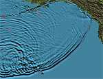 Still image captured from simulated tsunami propogation animation.
Click here to see this animation and others. Image courtesy Tsunami Research Program, Pacific Marine Environmental Laboratory (PMEL), NOAA. Animation of simulated tsunami across the Indian Ocean. National Institute of Advanced Industrial Science and Technology (AIST), Japan California Tsunami Models and Animations What might happen if there were underwater landslides and/or earthquake offshore California? See the model results. USC Tsunami Research Group Modeling and Forecasting Models of the North Pacific including animations. Tsunami Research Program, Pacific Marine Environmental Laboratory (PMEL), NOAA USC Tsunami Research Group "A new USC study shows that tsunamis - triggered by earthquakes and underwater slides - could threaten Southern Californias coast." By Bob Calverley, USC News Descriptive Model of the July 17, 1998 Papua New Guinea Tsunami Explains the reasons for this killer tsunami. Includes animations showing the results of model simulations. Western Region Coastal & Marine Geology, U.S. Geological Survey |
||||||||
|